


Feature image by Jordan Haworth.
Jillian Piper looks at how the storms that hit Ottawa and Gatineau formed, and if we can expect to see more in storms in the future
At 4:15 p.m. on Sept. 21, hundreds of thousands of phones across Ottawa lit up, rung, and vibrated, all having received the same message.
The Alert Ready System had sent the message, warning those in the Capital region of an incoming tornado.
In total, six tornadoes hit the Ottawa and Gatineau area that day. The tornado that hit the Dunrobin area, a small community in the west of Ottawa, was the most severe of all hitting a category three out of five on the Fujita scale, with winds of up to 265 kilometres per hour.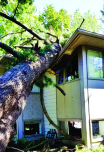
Across Ottawa and Gatineau, homes experienced damage, trees and power lines were toppled and there were widespread power outages, which lasted nearly a week for some.
Power was returned late on Wednesday to the last of the some 170,000 homes that experienced outages due to the storm. According to a statement from Ottawa’s mayor Jim Watson, 51 homes are in need of being rebuilt or structural repairs as a result.
According to Environment Canada meteorologist Gerald Cheng, the storm was an unusual one for the area.
“It’s very rare to have such a powerful tornado in Canada in September because we’re getting into the fall season, and what produces a tornado are thunderstorms,” he said. “Thunderstorms are more prevalent in spring and in summer.”
What is a Tornado?
Tornadoes occur when hot, humid air interacts with colder air, which causes instability in the air masses, resulting in high winds—and potentially a tornado, Cheng said.
Normally, he said, tornadoes are associated with thunderstorms, which is why it was strange for the tornadoes that struck the Ottawa/Gatineau area to occur. 
Residual high humidity air in the Ottawa/Gatineau area, Cheng says, interacted with an incoming cold front, a large mass of cold air known as a cyclone.
“It’s a matter of probability—when we have heat and humidity, we have the possibility of thunderstorms, but we need a trigger, and the trigger was that cold front that was coming into eastern Ontario, and that triggered the thunderstorms.” – Gerald Cheng, meteorologist with Environment Canada
Kent Moore, a University of Toronto professor and meteorologist said since this cyclone was so large, that explains why there were multiple tornadoes in the area.
“Normally, you would see one tornado at a time, because every thunderstorm would have one,” he said. “But, because there was this cold front coming
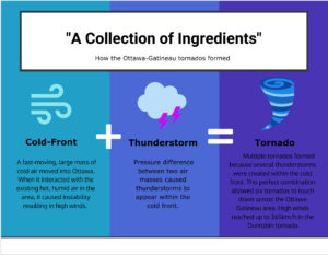
through, you had multiple thunderstorms embedded in that cold front and so that’s why you got the multiple tornadoes. But, usually they’re kind of isolated, so that was the unique thing about this event.”
Detection
Since tornadoes are most commonly associated with thunderstorms, which are normally very small weather systems, they are harder to track using radar weather detection systems, Moore said.
“Tornadoes may be only 500 metres in diameter. So, they’re very small-built systems,” he said. “You can see that in Ottawa, where one side of the street was demolished, and maybe on the other side there was some minor damage, so these things are very, very localized.”
Using a radar system can help combat some of the uncertainty, according to Moore, and more radar detectors help create a more accurate picture of what’s happening in an area.
“In the past 20, 30 years ago, we probably didn’t know just because we didn’t have very good coverage with radars,” he said. “Nowadays, we have fairly good coverage of weather radars. Models are probably now able to pick up the thunderstorms, but not every thunderstorm produces a tornado—you need special conditions within that thunderstorm to produce a tornado.”
In many cases, Moore says, confirmation that a tornado is taking place involves a visual confirmation from someone on the ground who can see the tornado actually taking place.
This was why the tornado that hit the Calabogie area just outside of Ottawa was not confirmed until Monday.
How common are tornadoes?
The tornado alley, which is the site of many of the tornadoes in the U.S. in states like Texas and Oklahoma, continues north of the border and splits west and east, continuing on through into the Prairies and the other branch through southern Ontario.
However tornadoes are more likely in the U.S., Moore said. This is because of close proximity of Tornado Alley to the Gulf of Mexico, which is a large source of hot and humid air.
As you move further north, the air is less humid and hot, which creates less thunderstorms and thus less tornadoes.
According to Environment Canada, roughly 60 tornadoes are observed in Canada each year, most of them taking place in the Prairies and southern Ontario.
However, meteorologist Alexandre Parent, in an article for the Toronto Star, said the weather models suggest the true number of tornadoes in Canada is closer to 200 each year.
Could this happen more often in the future?
As some now start the process of rebuilding their homes, one major concern is whether this kind of event will happen more in the future.
In recent years, Gatineau has suffered severe flooding, and now a tornado. In an interview with the Montreal-Gazette, Gatineau mayor Maxime Pedneaud-Jobin said, “In Gatineau, we’ve suffered a lot. We’re continuing to suffer and one of the main sources of that, it’s clear, is climate change.”
The claim that climate change will worsen and make more frequent weather events like Ottawa’s tornadoes, scientifically makes sense, Moore said.
“Just the basic physics tells you as the atmosphere gets warmer—there will be more water vapour and we can expect to see more storms.” – Kent Moore, professor at University of Toronto
However, he said there is no definitive proof yet that this will be the case.
“I don’t think we know the answer to that yet. What we do know is that in Ontario, temperatures have been increased by maybe two degrees Celsius in the past 40 years, and as the atmosphere gets warmer, it can hold more water vapour,” Moore said. “So, water vapour is like the fuel of a lot of these storms, so we would expect there to be more thunderstorms occurring, but I don’t think we can yet definitely say that that’s happening.”
Cheng said the increase in temperatures’s effect on extreme weather events, is something that will need to be studied and analyzed going forward.
“First, we need to study this particular area, in the Ottawa region. So, are we having more air masses that will lead to thunderstorms? Do we have more heatwaves or more humidity for longer during the year? It’s definitely something we should look at.”
However, at this current stage, Cheng said the storm that hit the Ottawa/Gatineau area does not represent a new trend emerging.
“For this particular effect, it was an accumulation of things that produced this particular effect, and for this collection of ingredients to come together again, it would have to be a coincidence,” he said. “Not saying it won’t happen, it’s just not very likely.”
Graphics by Paloma Callo.
Photo by William Fraser.